


Ground control point GCP

Contents |
[edit] Introduction
A ground control point (GCP) is a place or object with a known geographic location (or GPS coordinate) that can be used as a reference point to deliver a precise aerial map for surveying purposes. GCPs are built on the principle of recording the position of an object by calculating the distance and angles between strategically selected points. GPCs can make it possible to map large areas in aerial mapping surveys.
[edit] Parameters for GCPs
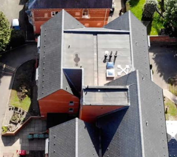
GPCs can be photo identifiable objects (such as a manhole cover) or a marked black and white symbol (such as the figure “X” painted on the ground or a small section of a checkerboard). Traditional surveying methods or existing maps can be used to locate the points, but other approaches - such as LiDAR or Google Earth - can also be used.
From an aerial photography perspective, GCPs are a traditional method of defining a location. High contrast colours can be used to make GCPs stand out on drone maps. They should have centrepoints that are clearly defined.
There are other parameters for creating GCPs, including spatial reference systems. These systems are used to relay positions in GCPs by defining several parameters, including:
- Reference ellipsoid. This is the geometric surface that represents the approximate shape of the Earth.
- Reference datum. This is the reference point that is used as the basis for the measurement of all positions.
- Geoid model. This representation of the Earth’s surface uses mean sea level as the reference point of measurement.
- Unit of measurement. This data should be clearly stated - degrees (in latitude and longitude, metres or feet) in relation to how the GCP will be measured in relation to the reference datum.
- Map projection. The method of converting the map from a 3D ellipsoid into a flat plane applies a formula referred to as coordinate transformation.
[edit] Advances in drone surveillance
While GCPs have been a tested method of aerial mapping, there are some inefficiencies associated with the method. There can be logistical challenges when obtaining authorisation for access. In some cases, it may not be possible to gain physical access to the area, even once permission has been granted, due to dangerous terrain or hazardous or remote locations.
In addition, set up can involve a significant amount of time, labour and equipment.
There are several types of equipment that use differential correction technology to provide better data location information; this essentially removes the need for GCP set up. The most commonly used options are real time kinematic (RTK) and post processed kinematic (PPK). RTK makes real time corrections to images captured by GPS while PTK corrects location data after it has been collected and uploaded. In some instances, it can be helpful to use GCPs to enhance information gathered by RTK or PPK enabled technologies, particularly in instances where it is important to capture certain types of precise data regarding accuracy of scale, orientation and so on.
[edit] Related articles on Designing Buildings
- Construction drones.
- Global positioning systems and global navigation satellite systems.
- Ground sample distance GSD.
- Interview with Elly Ball, co-founder Get Kids into Survey.
- Land surveying.
- Laser scanning for building design and construction.
- Post processed kinematic PPK.
- Real time kinematic RTK.
- Universal transverse mercator projection.
- Uses of drones in construction.
Featured articles and news
International Electrician Day, 10 June 2025

Celebrating the role of electrical engineers from André-Marie Amperè, today and for the future.
New guide for clients launched at Houses of Parliament

'There has never been a more important time for clients to step up and ...ask the right questions'
The impact of recycled slate tiles
Innovation across the decades.
EPC changes for existing buildings
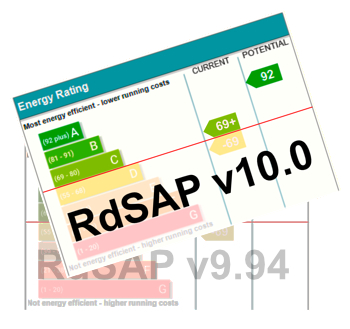
Changes and their context as the new RdSAP methodology comes into use from 15 June.
Skills England publishes Sector skills needs assessments

Priority areas relating to the built environment highlighted and described in brief.
BSRIA HVAC Market Watch - May 2025 Edition
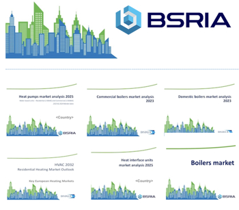
Heat Pump Market Outlook: Policy, Performance & Refrigerant Trends for 2025–2028.
Committing to EDI in construction with CIOB

Built Environment professional bodies deepen commitment to EDI with two new signatories: CIAT and CICES.
Government Grenfell progress report at a glance
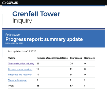
Line by line recomendation overview, with links to more details.

An engaging and lively review of his professional life.
Sustainable heating for listed buildings

A problem that needs to be approached intelligently.
50th Golden anniversary ECA Edmundson apprentice award
![]()
Deadline for entries has been extended to Friday 27 June, so don't miss out!
CIAT at the London Festival of Architecture
![]()
Designing for Everyone: Breaking Barriers in Inclusive Architecture.
Mixed reactions to apprenticeship and skills reform 2025

A 'welcome shift' for some and a 'backwards step' for others.
Licensing construction in the UK

As the latest report and proposal to licence builders reaches Parliament.
Building Safety Alliance golden thread guidance
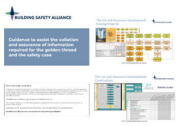
Extensive excel checklist of information with guidance document freely accessible.
Fair Payment Code and other payment initiatives

For fair and late payments, need to work together to add value.
Pre-planning delivery programmes and delay penalties
Proposed for housebuilders in government reform: Speeding Up Build Out.
High street health: converting a building for healthcare uses

The benefits of health centres acting as new anchor sites in the high street.